#GrandCanyon #JacobLake #Arizona
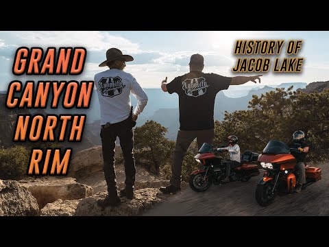
Exploring the North Rim of the Grand Canyon on two wheels was one of the most eye-opening experiences we’ve had to date, and we’re excited to be sharing it! We start out in Jacob Lake, interviewing Melinda Rich, who’s family founded Jacob Lake and has operated the Inn at the junction for nearly 100 years! After learning about some great history, we hop on the bikes to explore some of the most scenic roads in all of the country! We stop at Point Imperial, Bright Angel Point, and Cape Royal, to overlook some of the best views the North Rim has to offer.
Instagram: https://www.instagram.com/2lanelife/
⬇️⬇️ BLOG w/ EATS, MAPS, STAYS, AND LANDMARKS ⬇️⬇️
(Coming Soon)
https://2lanelife.com/blogs/news/
USE CODE: "YOUTUBE" FOR 10% OFF OF PARTS & ACCESSORIES
https://2lanelife.com/
North Rim of the Grand Canyon
The North Rim offers a serene and enthralling Grand Canyon experience. It is more remote and less developed than the South Rim, and so it attracts far fewer tourists. Many people think its viewpoints are the most spectacular, since they are located at a higher elevation.
The North Rim sits atop the Kaibab Plateau at an elevation between 8,000 and 9,000 feet, about 1,500 feet higher than the South Rim. The higher elevation environment of the North Rim includes mixed conifer forest with stands of aspen that turn gold in fall. Be prepared for cooler temperatures with freezing nights possible as late as May and as early as September.
North Rim Scenic Drive
Point Imperial and Cape Royal are reached via a winding scenic drive. The trip to both points, with short walks at each and several stops at pullouts along the way, can easily take half a day.
Point Imperial, the highest point on the North Rim at 8,803 feet (2,683 meters), overlooks the Painted Desert and the eastern end of Grand Canyon. Here the canyon transforms as the narrow walls of Marble Canyon, visible only as a winding gash, open dramatically to become "grand." Layers of red and black Precambrian rocks, not visible at Bright Angel Point, add contrast and color. Part of the viewpoint is accessible.
Cape Royal provides a panorama up, down, and across the canyon. With seemingly unlimited vistas to the east and west, it is popular for both sunrise and sunset. The sweeping turn of the Colorado River at Unkar Delta is framed through the natural arch of Angels Window.
Kaibab Forest
Many other options exist in the North Kaibab Forest. The Kaibab Plateau-North Rim Scenic Byways winds through meadows and forests ending at Grand Canyon National Park’s North Rim. Over 300 miles of trails, some clinging to the rim of the Grand Canyon, offer a diversity of challenge and solitude – and spectacular views only shared by local wildlife.
Jacob Lake History
Jacob Lake Inn was founded in 1923 by Harold I. Bowman and his wife Nina Nixon Bowman to facilitate tourists attempting to reach the Grand Canyon. Nina's grandfather, Franklin B. Woolley, had been involved in some of the first mapping expeditions in southern Utah and northern Arizona. Harold's father, Henry E. Bowman, was also a successful merchant.
Jacob Lake Geography
Jacob Lake is situated at an elevation of roughly 8,000 feet (2,400 m) in a large ponderosa pine forest which is part of the Kaibab National Forest. In its lower elevations, the Kaibab Plateau consists of pinon-juniper forests, and the ponderosas give way to aspen, spruce, and fir higher up.
The town is roughly a mile from Jacob Lake. This pond was named for Jacob Hamblin, an early Mormon pioneer of southern Utah and northern Arizona. He was shown its location probably in 1858. by the Kaibab band of Southern Paiutes who summered on the plateau, and with whom he was on friendly relations.
Though small, the lake was a permanent source of water which was a rarity on the porous Kaibab Limestone. Known to some as the "waterless mountain," in pioneer days the Kaibab was called the "Buckskin Mountain," but the name itself is a Paiute word meaning "mountain inside out," or "mountain lying down." However, Jacob Lake's situation and permanent water made it an important stopping place for travelers moving from Utah into Arizona.
CHAPTERS:
00:00-03:02 - PREVIEW/INTRO
03:03-15:43 - HISTORY OF JACOB LAKE
15:44-19:53 - RIDING TO THE VERMILLION CLIFFS
19:54-31:14 - BRIGHT ANGEL POINT
31:15-36:07 - POINT IMPERIAL
36:08-43:21 - ANGELS WINDOW & CAPE ROYAL
Friends:
https://www.thrashinsupply.com/
https://www.feulingparts.com/
https://www.legendsuspensions.com/
https://www.getklocked.com/
https://cobrausa.com/
https://www.maximausa.com/
https://www.bellhelmets.com/motorcycle/
https://www.saddlemen.com/
https://galferusa.com/
https://rockfordfosgate.com/motorcycle/
Produced by 2LANELIFE PRODUCTIONS
Edited by Josh Seiden
https://www.instagram.com/j.biiird/
https://www.instagram.com/2lane.jay/
https://www.shotsbyseiden.com/
- Category
- Highway Men
Commenting disabled.
Up Next
-
21:44

Riding Harleys in the POURING RAIN to Tombstone Arizona and Beyond | Laidlaw Crew x 2LaneLife Ride
-
16:16
Riding from Salt Lake City, UT to Jackson, Wyoming | Logan Canyon, Bear Lake & More | 2LaneLife | 4K
-
09:46
Riding Harleys to a Lake Powell Boat Tour | 2LaneLife Clips | 4K
-
25:36
Riding Harleys from Massachusetts to Maine | Group Ride | History, Food, Riding & More! | 2LaneLife
-
24:20
Riding Harleys on the Tail of the Dragon & Cherohala Skyway! | 318 Turns, 11 Miles | 2LaneLife
-
Jhonny Caz es Gay | Grupo firme explica el video de Enloquéceme
-
Baalveer Returns - Ep 171 - Full Episode - 18th August 2020
-
10:59

Steel Head vs. Bruce Lee (EA sports UFC 3)
-
06:42

I Will Rock & Roll with You - w Tom Astor
-
Garth Brooks Greatest Hits Full Album - Friends In Low Places Garth Brooks - Best Songs Garth Brooks
-
Country Roads by John Denver & Johnny Cash | What a Cool Duet! | Music Reaction Video
-
IF TOMORROW NEVER COMES - Garth Brooks - recorded live @Colin Wardale
-
Norsk duo kör Lasse Stefanz låtar
-
03:52

Lasse Stefanz. En man som han. Live. Malung Orrskogen 19 juli 2023.
-
Ring Of Fire - Johnny Cash & Dj Serj Moldova (remix)
-
Gigg !! Jimmy Dahl Rydöbruk - Rydö-House-Band giggar lite dansband i kväll ????????????
-
Country Monster Versus Johnny Cash - If I Were a Carpenter - Round 1
-
1:58:42

¡MLW y 915-656 presentan Fury Road! Lucha Estelar: Alex Hammerstone vs Willie Mack
-
03:44
Kris Kristofferson @The City Winery, NY 4/27/19 Casey's Last Ride
-
Rita Fotland Bøe & Kåre Bøe "Jag vill se dig lycklig"
-
Sin & Chrome - Dáv Mikals & BLACK TRAIN 27
-
02:13

Gvllow - Johnny Cash (BMW M6 Music Video)